GIS Extension for NetLogo Goes 1.0

Eric Russell’s GIS extension for NetLogo has been released as a 1.0 version. Eric has licensed it as fully open source, in the hopes that it will be developed further by the community, which is great. It will come bundled with the 4.0.3 version of NetLogo, which is due out shortly (and will not be open source at all. When CCL? When?).

It’s too bad the upcoming Language as a Complex Adaptive System conference won’t have a poster session, or I’d use the GIS extension to roll some realistically spatial population-distribution data into my accent formation model and see if it generated any interesting results to poster up.

Attempting to Enlist Google Earthers for My Research

I’m trying to find some additional study sites for my research. I’ve recently realized how stupid I’ve been by not using Google Earth as my main exploratory site-search tool. Way way waaay faster than trying to download overview imagery raw from USGS or wherever. It also occurred to me that there are thousands of people who cruise around in Google Earth every day, looking for interesting things and talking about it in the forums. So I posted there, in case anybody might have seen the kinds of semi-arid plant patterns I’m looking for. I’m interested to see if there will be any response.

update: the post has been moved to the “Moderated” section of the Nature and Geography forum. The above link has been updated.

study site in Arizona
A study site in Arizona.

GIS Extension for NetLogo Released

Eric Russell has released an early-development version of an extension for using GIS data in the NetLogo agent-based modeling environment. This is fairly large good news to a fairly small group of people. I’m one of them.

In addition to bringing raster-based data into NetLogo models (such as using USGS elevation data in this Grand Canyon model that Eric previously contributed to) the extension allows for import of vector data in the form of shapefiles. The shapefile format is openly-documented, but that still can’t have been easy to build. Assuming it works, doing so should substantially lower the barrier to integrating truly interesting real-world data into agent-based models, especially for people who don’t want to dedicate the bulk of their effort to that task.

I haven’t tried it yet, so I can’t speak to stability. Installation looks to be pretty easy though. It’s very possible this will come in very handy with my pending research.

(insert routine when-will-NetLogo-go-open-source gripe here.)

Was the Farley Mowat in International Waters?

Paul Watson of the Sea Shepherds is calling it an act of war. The Farley Mowat was seized by teams of “emergency response” mounties deployed in zodiacs from a pair of coast guard ice breakers. Nobody is yet saying exactly where it happened, but apparently they were somewhere in the Cabot Strait, between Cape Breton and Newfoundland. Watson says they were in international waters. The Fisheries Minister, Loyola Hearn, says they were in “internal waters”. That’s a giant difference in interpretation.

So without knowing just exactly where it went down, is either claim reasonable? At the wikipedia level of analysis, the answer is yes.

Territorial waters” are measured from the low-tide shore baseline 12 nautical miles out to sea. Within it’s territorial waters Canada has legal sovereignty, presumably similar to the legal status of national terrestrial territory. There is an exception requiring free “innocent passage” of vessels, but I doubt if the Farley Mowat could claim they were on a mission of good order and security.

There’s something else called a “contiguous zone” which countries can optionally claim out to 24 nautical miles. Canada does, but it doesn’t seem like it has much serious jurisdiction over that zone.

Here’s what I figure for the territorial waters and contiguous zone of the area, all other things being equal:

territorial waters off the coast of cape breton

By that measure it looks like the Farley Mowat would have had plenty of room for free sailing. Even if they needed to make passage into the Gulf of Saint Lawrence, they could have kept outside of Canadian sovereign terrority.

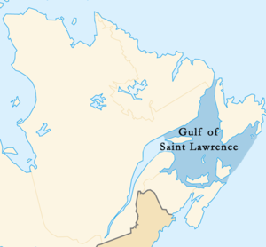
But as far as I can tell Minister Hearn hasn’t actually been directly quoted using the language of territorial waters. He’s talking “internal waters”. Internal waters are also sovereign territory. The wikipedia definition makes it sound like you pretty much need to inland to be internal. Interestingly, Canada makes a number of exceptional claims to “internal waters” that don’t seem to come even close to fitting that definition. Most controversial at the moment is a chunk of the newly-navigable northwest passage. Also however, the Gulf of Saint Lawrence. Once again, according to wikipedia, the Gulf estuary (the worlds largest estuary!) covers the area between Cape Breton and Newfoundland. By definition, from the looks of it:

wikipedia's take on the gulf of saint lawrence

It’s worth noting that within internal waters, there’s no right of even innocent passage.

So was the Mowat attacked by mounty pirates when she was boarded, or was it an legitimate arrest? If you accept Canada’s claim that the 1000s of square miles of heaving grey Atlantic in the Cabot Strait are “internal waters”, then it looks like this a purely internal affair. If you’re dubious of that claim, then it gets interesting.

But even if it was a high-seas boarding, it won’t rank as especially crazy on the Canadian-fisheries high-seas boarding scale of craziness. Back in 1995 the Coast Guard forcefully boarded a trawler that wasn’t in internal waters, wasn’t in territorial waters, and wasn’t even in the 200 mile economic zone.

From the federal court record:

“On the 9th of March, 1995, at or about 18:15 (6:15 p.m.)[1], armed boarding parties from three (3) or four (4) Canadian vessels boarded the Spanish deep-sea freezer-trawler ESTAI (the “ESTAI”) within the Northwest Atlantic Fisheries Organization (“NAFO”) Regulatory Area, which is to say outside Canadian fishery waters or, put another way, on the high seas. The boarding parties, which may have included members of a Royal Canadian Mounted Police (“RCMP”) emergency response team, arrested the ESTAI.”

(emphasis added)

From ever-trusty wikipedia:

On March 9 offshore patrol aircraft indicated a likely candidate and several armed DFO offshore fisheries patrol boats, along with Canadian Coast Guard and navy support, pursued the Spanish stern trawler Estai in international waters outside Canada’s 200 nautical mile (370 km) EEZ. The Estai cut its weighted trawl net and fled, resulting in a chase which stretched over several hours and ended only after the Canadian Fisheries Patrol vessel Cape Roger firing of a .50 calibre (12.7 mm) machine gun across the bow of the Estai. The Canadian Coast Guard Ship Sir Wilfred Grenfell used high-pressure fire-fighting water cannons to deter other Spanish fishing vessels from disrupting the enforcement operation. Finally, armed DFO and RCMP officers boarded the vessel in international waters on the Grand Banks and placed it and its crew under arrest.

(emphasis added)

Open Access Spatial Data Could Have Bumped Australian GDP 7%

This seems a little hard to credit at first blush, but a report from somebody called the Cooperative Research Centre for Spatial Information is claiming that lack of open access to spatial information might have cost the Australian GDP about 7%. Damn. Here’s Open Access New reporting on the subject.

Walking On the Moon

There’s something compelling about this map of the walking paths of the Apollo 11 astronauts on moon, superimposed on a baseball diamond for scale.

Like, they were really there walking around on the holy crap moon.

A bit. They didn’t go very far. If I was on a brand new world I wouldn’t go far from the car either.

Vantreight Farms’ Non-Daffodil Developments

In the late winter of 2006 I worked as a picker at Vantreight farms, which if I remember correctly is the second largest daffodil farm in the world. At the time there was much controversy and knowing unspokeness around the farm fields because Geoffrey Vantreight Jr., the grandson of the founder, had just passed away and his sons were feuding over what to do with the property. With real estate value what it is in the Victoria region (and the Saanich peninsula being drop dead gorgeous in certain lights and from certain angles, which I had plenty of opportunity to experience bouncing out in the farm bus as the sun came up), the land the flowers are grown on is arguably worth far far more than the flowers will ever sell for. On the other hand, the land is in the Agricultural Land Reserve, which is a sort of functional greenbelt and which requires a lot of baksheesh to the Victoria City Council before you can develop in it. As I was slogging up the muddy rows of maturing daffodil stems with my pairing knife, the entire matter had landed in some sort of court or binding arbitration, and the future pre-summer livelihood of Quebecois hippies, Punjabi-Canadians, migrant Mexican labourers and the occasional aimless BSc. was hanging in the balance.

According to a slick new addition to the daffodil.com website, it appears the matter has been resolved. A fancy flash interface will show you a series of map overlays which propose a

“mixed-use housing development on land that is not farmable or in the Agricultural Land Reserve (ALR) featuring 31 single-family homes, 92 townhomes, and 141 condominium units. Net revenue generated from the proposed development of this land will be invested back into Vantreight Farms, which grows approximately 18 million daffodils per year, generating 1,500 to 2,000 jobs annually. This development is essential for Vantreight Farms to modernize and expand its operations and also to assist us in becoming economically, environmentally and socially sustainable for generations to come.”

Interesting. Judging from the amount of money they’ve spent on GIS and web development, I’d say there must be some ongoing controversy they’re trying to allay.

update: Shortly after posting this I got a call from Ryan Vantreight, grandson of Geoff Jr., who was concerned about some of what I said in this post. He offered some extra information, which I’m happy to present here (I hope this is an accurate summary of Ryan’s main points)

  • Geoff Vantreight Jr. passed away in 2000, not 2005.
  • There was indeed a court-adjudicated dispute between the Vantreight brothers, Ian and Michael. My rough understanding is that each of them owned a part of the land, and for the farm to be viable all the land would be needed (that’s my recollection, not what Ryan told me, it may not be exactly right). Ian wanted to buy out Michael’s half, and Michael wanted to sell outside the family.
  • Michael won the case, granting him the right to sell to anyone and especially not to Ian. Ryan, who is Ian’s son, worked to convince the two brothers to reach an agreement regardless of the court decision, and Michael subsequently agreed to sell to Ian.
  • The sale was made, with the intention of keeping the entire property as farm. The cost of the buy-out meant a lot of debt, which currently hangs over the farm’s head.
  • Vantreight Farms, like most in Canada, is suffering from decreasing margins and increasing costs.
  • The consequence of all this is that the Vantreight Hill development proposed on the website is an effort from the pro-farming side of the family to raise money to cover the debt and modernize the farm to make it more financially viable.
  • (I’m not too worried that modernization would mean the end of seasonal picking on the farm. I’ve watched Star-Wars-esque machines, under the control of a couple of guys, harvest an acre of California cotton in 15 minutes which would have taken dozens of pickers a day back in the day. But I have a hard time imagining how any similar machine could harvest daffodils of just the right stem length without enormous wasteage, too much to be affordable. I think.)

  • Ryan particularly emphasized that the development is (as I quoted in the original post), not in the ALR or farmable land. Having looked up to it from the trenches many cold and hot days in the fields, I can verify that it doesn’t look like anything you can farm on.
  • He also suggested that part of the farm modernization would include extra crop rotation and other environmental improvements. Further details regarding those improvements are expected to be on the website in the near future assuming the project proceeds.
  • Monday is the day that the whole issue goes to council for a green or red light. I asked if their were other options if it was turned down and Ryan said that this is the first in a series of make-or-break challenges to the development. The results will be posted on the website
  • I’m in no position to verify or dispute any of this of course, but Ryan certainly sounded like a reasonable guy. I carry a deep and I think justified suspicion of residential development around Victoria (think Bear Mountain and shudder), and a condo development for a condo development’s sake isn’t much to celebrate. But I like the daffodil farm and remain grateful for the paid work I did there. Nor can I rule out doing some more of it. Vantreight farms is a couple of rare things — a large yet family owned enterprise, and a (so far) functioning farm. If Vantreight Hills is what’s required to keep the farm afloat, then it can at least be said that there are less justified condominium development proposals in the world.

    Moran’s I in Netlogo

    It’s crazy go nuts week here in graduate student land, as final projects and final exams go off like mortar rounds all around us. Duck and cover! “Graduate student”. Oxymoron.

    Yesterday I submitted my term project for my data analysis class: an implementation of Moran’s I statistic for measuring clustering in spatial data, built in the NetLogo agent-based modeling environment.

    Moran’s I is a bit dated now I suppose, especially if you ask an up-to-date geostatistician, but everybody still uses it because it’s what everybody knows. And who has up to date geostatisticians hanging around to ask these questions of? If you’ve got a NetLogo model and you want a basic measure of spatial autocorrelation of the results, feel free to use and abuse the code. I managed to port it into my NetLogo accent formation model.

    Be warned: it’s not 100% statistically valid or validated. I would be careful about reporting strong claims of “statistically significant clustering” until you’ve either improved on it or carefully characterized the results in your own model. But I think it’s reasonable as an ad hoc measure of clustering to parachute into whatever needs one.

    Before I had this thing running, the measure of autocorrelation I was using in my accent model was to crank out a semivariogram for all the point pairs, add up the average value-distance for all the pairs on the “near” half of the variogram, add up the average for the “far” half, and compare the ratio of the “near” and “far” averages. Ouch. I called it the “near-far index”. In fact, let’s call it “Stimson’s near-far index”. Don’t use it for God’s sake. When presenting my Moran’s I improvement, I kind of had to describe the Stimson’s statistic it was replacing. Pierre Goovaerts was in the room. I felt his friendly Belgian eyes burning into my back with incredulity. Ouch.

    Animated Model of Oil Spills on the BC Coast

    The Living Oceans Society have put together an animated interactive model of hydrologically realistic oil spill scenarios on the BC coastline. It has lots of features, but it can be comprehended faster by using it than having it described, which is a great thing. You can add bird habitat, fish migration routes and the like to the map, then watch them get obliterated when the ocean currents turn the wrong way. It’s super cute, and appropriately scary.

    Oil shipping, processing and extraction has been strongly regulated in BC, but a number of serious threats have been coming up in the last few years (e.g. there is a long-standing moratorium on even exploring for oceanic oil off the BC coast, but the government is now claiming that it can’t find the piece of paper where that was written down). Public opposition has been strong and will get stronger. This model contributes to that discourse with a nice mix of modeling, GIS and infoporn.

    Footnotes on their data sources and processing techniques are here.

    OpenStreetMaps: You Can Has Interesting Maps

    As part of my series of ‘quality blogposts I will eventually get around to writing’ (see also further notes on making websites from open source CMSs and comparing music player software), I’m working on some hows and whys to make embedded website maps using open source tools. Inevitably, this isn’t that. But I did come across this website and I figured it was worthy of a shout out:

    OpenStreetMap

    OpenStreetMap is a project aimed squarely at creating and providing free geographic data such as street maps to anyone who wants them. The project was started because most maps you think of as free actually have legal or technical restrictions on their use, holding back people from using them in creative, productive or unexpected ways.

    Their mediawiki powered, cc-wiki licensed website is amateurish but that’s not necessarily a bad thing in my estimation. Sometimes amateur websites suffer from poor informational design, but this is one of the better I’ve seen. The “I want to see maps; get out of my way!” link square at the top of the front page may be a bit cute but it does the job. The ‘lolcat of awesomeness’ they hand out to special contributors may be way too cute but well, it does the job. The whole thing comes off as active, friendly, and telegraphs how to get deeper in, rather than intimidating the new visitor by suggesting how much deeper in you would have to go to figure anything much useful out.

    lolcat of awesomeness, I'm afraid

    And they’re an open-access street map project. How cool is that?

    ← newer posts · older posts →